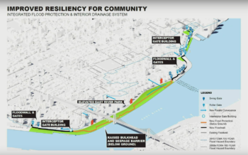
The project is predicted to protect over 110,000 Lower Manhattan residents from flood and storm impacts. On September 23, 2019, the City Planning Commission voted to approve two applications regarding the East Side Coastal Resiliency Project which addresses coastal flood vulnerabilities in Lower Manhattan. The project area is bounded by East 25th Street to the north, Montgomery Street to the south, and the East River to the east. The area runs along the FDR Drive … <Read More>
Search Results for: Text Amendment
City Council Approves Major Bay Street Corridor Plan with Modifications

Before reaching the City Council, the project received mixed support over concerns that the area was ill-equipped for the increased density. On June 26, 2019, City Council voted to approve with modifications an application that would help implement a major City-initiated plan to redevelop Staten Island’s Bay Street Corridor, which connects the St. George, Tompkinsville, and Stapleton neighborhoods. The comprehensive plan will redevelop the Bay Street Corridor into a walkable, transit-oriented community that provides … <Read More>
DCP Announces New NYC POPS Logo
The winning logo was chosen from 607 submitted designs from around the world. On May 20, 2019, the Department of City Planning, the Advocates for Privately Owned Public Space and the Municipal Art Society of New York unveiled the new NYC POPS logo, which will be displayed at all 550 POPS locations across the city.
Major Staten Island Project OK’d by City Planning Despite Significant Opposition; City Council Up Next
The proposed zoning actions were largely disapproved by the Community Board, the Borough President, and even Staten Island’s appointee to the City Planning Commission. The Department of City Planning, along with the Department of Housing Preservation and Development and the Department of Citywide Administrative Services filed an application requesting several ULURP actions to help implement the goals of the Bay Street Corridor Neighborhood Plan. The Neighborhood Plan is a comprehensive plan to … <Read More>
City Planning Certifies City Applications to Build Borough-Based Jails

The four jails are set to replace Rikers island by 2027. On March 25, 2019, the City Planning Commission certified the City’s application for four borough-based jails as a part of the City’s plan to shut down Rikers Island. The four jails – in Manhattan, the Bronx, Queens, and Brooklyn – will have a total of 5,748 beds and a capacity of 5,000 inmates. The additional 748 beds will be used to account for taking … <Read More>
Coney Island Rezoning Fails Following Community Concerns

City Planning voted no in part to questions regarding alleged comments made by project attorney at Community Board hearing. On January 9, 2019, the City Planning Commission voted to disapprove a proposed rezoning of the northern portion of a block situated between Surf Avenue to the north, Reigelman Boardwalk to the south, West 22nd Street to the east, and West 23rd Street to the west, in Coney Island, Brooklyn. The rezoning would have … <Read More>