The sustainable-design building would offer on-site supportive services and comes with several amenities for tenants. On July 31, 2019, the City Planning Commission held a public hearing on an application to convert City-owned property at 776-780 Myrtle Avenue in Brooklyn to a nine-story affordable and supportive housing development. The applicant team is comprised of the Department of Housing Preservation and Development, IMPACCT Brooklyn, and Urban Architectural Initiatives. To facilitate the development, the … <Read More>
Search Results for: Site Designation
DCP Launches Citywide Map for Supermarkets

Newest interactive tool helps communities evaluate supermarket needs. On August 2, 2019, the Department of City Planning launched the Supermarket Needs Index, a new interactive online map that shows fresh food store access across New York City. The map highlights which neighborhoods are underserved or lacking grocery store options.
City Council Approves Major Bay Street Corridor Plan with Modifications

Before reaching the City Council, the project received mixed support over concerns that the area was ill-equipped for the increased density. On June 26, 2019, City Council voted to approve with modifications an application that would help implement a major City-initiated plan to redevelop Staten Island’s Bay Street Corridor, which connects the St. George, Tompkinsville, and Stapleton neighborhoods. The comprehensive plan will redevelop the Bay Street Corridor into a walkable, transit-oriented community that provides … <Read More>
Landmarks Designates Bay Ridge’s First Historic District
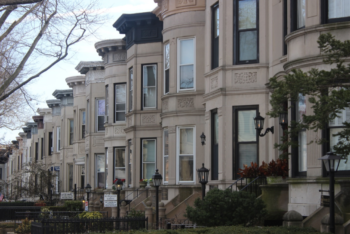
The 100-year-old block stands out in the neighborhood for its high architectural quality and aesthetic consistency. On June 25, 2019, the Landmarks Preservation Commission voted to designate Bay Ridge’s first historic district, “Bay Ridge Parkway – Doctor’s Row.” The new historic district is comprised of 54 two-story and basement rowhouses located on a prominent 100-foot wide, tree-lined block along Bay Ridge Parkway between 4th and 5th Avenues in Brooklyn. The rowhouses were all … <Read More>
City Planning Hears Proposal to Convert Three City-Owned Properties to Affordable Housing
All three proposed buildings would come with amenities for residents including outdoor areas and laundry rooms. On June 19, 2019, the City Planning Commission held a public hearing on an application to convert three City-owned properties located in the East New York neighborhood of Brooklyn to new affordable housing buildings. All three properties are currently vacant. The three proposed buildings would result in 41 affordable units and one superintendent’s unit.
Landmarks Designates Sunset Park Historic Districts
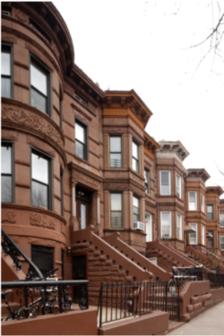
The four historic districts contain the most cohesive intact concentrations of high-quality architecture in Sunset Park, representing its primary periods of development. On June 18, 2019, the Landmarks Preservation Commission voted unanimously to designate four areas of Sunset Park, Brooklyn as historic districts: Sunset Park North, Sunset Park South, Central Sunset Park, and Sunset Park 50th Street. Sunset Park North, South, and Central Sunset Park Historic Districts are areas where coherent historic streetscapes continue … <Read More>