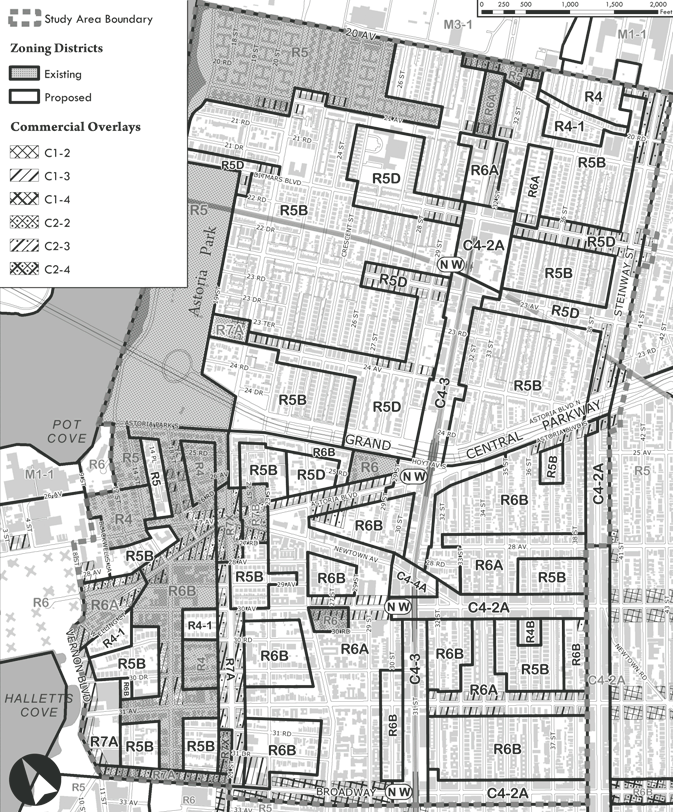
Astoria’s 238-block contextual rezoning received strong support from Council Member Vallone. On May 25, 2010, the City Council approved the Department of City Planning’s contextual rezoning plan for Astoria, Queens. The plan impacts 238 blocks bounded by 20th Avenue to the north, Broadway to the south, Steinway Street to the east, and the East River and Vernon Boulevard to the west. The rezoning replaces the area’s predominant R5 and R6 zoning with contextual zoning districts, … <Read More>
Search Results for: Senior Housing
Height limits for Astoria considered
Local Council Member and residents supported the proposed 248-block contextual rezoning, but two property owners requested modifications. On March 24, 2010, the City Planning Commission heard testimony on the Department of City Planning’s contextual rezoning plan for Astoria, Queens. The 248-block study area is generally bounded by 20th Avenue to the north, Broadway to the south, … <Read More>
Staten Island’s Sandy Ground area downzoned
Rezoning proposed to prevent attached homes in area settled by freed slaves in 1827. On February 3, 2010, the City Council approved State Senator Andrew J. Lanza’s rezoning proposal for the Sandy Ground neighborhood of Staten Island. Sandy Ground, also known as Rossville, is listed on the National Register of Historic Places and recognized as one of the country’s oldest communities established by freed slaves. The rezoning impacts 35 blocks generally bounded by the West … <Read More>
EDC plan for 30-acre waterfront development approved
Council approved plan after EDC made further concessions on affordable housing. On November 13, 2008, the City Council voted to approve the NYC Economic Development Corporation’s Hunter’s Point South plan, a mixed-income 30-acre waterfront development in Long Island City, Queens. The project met with controversy at Council’s October 24th Zoning & Franchises Subcommittee public hearing and at the City Planning Commission’s August 13th public hearing. Opponents testified that the project lacked a sufficient amount of … <Read More>
City Planning action affects 1,000 acres in Staten island
Council Member Lanza and City Planning push forward Prince’s Bay down-zoning. On October 11, 2006, the Planning Commission approved a proposal to down-zone an 172-acre portion of Prince’s Bay, Staten Island and to adopt text amendments to restrict future development on an additional 830 acres. Council Member Andrew Lanza withdrew his original rezoning application … <Read More>
NY Elections, Census and Redistricting Update 08/12/24

by Jeff Wice & Alexis Marking
ELECTIONS
State Board of Elections Sued Over the Equal Rights Amendment’s Ballot Language
A new law enacted last year requires ballot language for voter referendum questions in New York State to be written in plain language at “no higher than an eighth-grade reading level.” The ballot language for the Equal Rights Amendment (ERA), which was approved to appear on the November ballot, has … <Read More>


