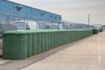
Interim flood barriers at Red Hook. Image Credit: NYC DDC
The protection measures consist of barriers that are capable to be opened or closed to mitigate the effects of storm surge flooding. On August 3, 2021, the New York City Emergency Management Department and Department of Design and Construction announced the completion of Interim Flood Protection Measures at the Atlantic Basin in Red Hook. The Interim Flood Protection Measures program began in 2016 to protect facilities, infrastructure, and low-lying areas all located in New York City from flooding caused by hurricanes.
Red Hook was determined to be a priority site for flood protection through the Flood Protection Measures risk assessment program. City agencies worked with consultants and other agencies to evaluate flood risks, perform assessments, and determine the best measures to reduce flood risk at each location.
The New York City Emergency Management Department led the project with support from the Mayor’s Office of Climate Resiliency and the Department of Design and Construction. The program also receives assistance from the Department of Transportation, Department of Environmental Protection, the New York City Economic Development Corporation, and the Port Authority of New York and New Jersey.
The Atlantic Basin Interim Flood Protection Measures includes a combination of barriers with various openings for normal site operations. These barrier openings are able to close when coastal storms that could cause storm surges are forecast. The barriers are capable of being closed using just-in-time deployable protection measures. These measures provide short term protection while permanent mitigation is constructed at the site.
The sites completion coincides with peak hurricane season in New York City which runs from August until October. The Red Hook site is the last planned installation of the program. The site will receive a permanent protection installation from the Red Hook Coastal Resiliency Project at another date.
New York City Emergency Management Commissioner John Scrivani stated, “With the addition of IFPM at the Atlantic Basin, low-lying, vulnerable areas in the neighborhood receive some added protection from potential storm surge.”
Director of the Mayor’s Office of Climate Resiliency Jainey Bavishi stated, “The City is advancing a two-part strategy to make Red Hook safer and more resilient. The temporary measures that have just been completed will provide immediate protections against coastal flooding. At the same time, we are continuing to work with the community to design a permanent coastal resiliency project that will provide long-term protections.”
By: Patrick McNeill (Patrick is the CityLaw intern and a New York Law School student, Class of 2022.)


Comment from the award-winning, maritime nonprofit PortSide NewYork in Red Hook, Brooklyn, NYC
Here is our Facebook live coverage of the press event related to the news above. https://www.facebook.com/portsidenewyork/videos/886964632175827
We and all locals we have spoken to spoken to say that the sandbags do not go around the complete perimeter of Red Hook, so we don’t know how this protects Red Hook from a major flood with seawater coming up and over the peninsula.
In addition, Red Hook is at the bottom of the watershed and sewershed, so during Sandy, we had geysers over storm drains, sewage coming up via toilets into homes, and underground streams burbling up. A local resident who worked for Red Hook NYCHA in maintenance told us that water came up into NYCHA cellars for 4 days.
PortSide did a lot of Sandy recovery prevention and recovery work, winning us a “Champions of Change” award from the White House. We were appointed to multiple government resiliency committees, the most important being the NYS NY Rising program. We have done extensive resiliency planning work about flood protection since Sandy. We have a Resiliency 101 section in our virtual museum Red Hook WaterStories at https://redhookwaterstories.org/tours/show/9