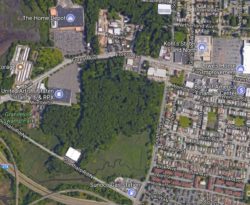
Satellite View of Project Area. Image Credit: Google Maps.
City Planning approved a special permit and City Map amendment to allow for the development of 5 one-story retail establishments in Mariner’s Harbor, Staten Island. On September 6, 2017, the City Planning Commission issued a favorable report on the South Avenue Retail Development. The South Avenue Retail Development involves 2 land use actions: a special permit to allow retail establishments above 10,000 square feet, and a City Map amendment to alter and remove unbuilt streets mapped over wetland areas. The Commission found both land use actions appropriate, subject to specific conditions.
The project area, the region southwest of Forest and South Avenues, is currently zoned as an M1-1 district. M1-1 zoning allows “light industrial and commercial uses as-of-right up to a floor area ratio of 1.0.” Commercial use in excess of 10,000 square feet is not allowed as-of-right, but can be overcome with a special permit from the Commission pursuant to Section 74-922 of the Zoning Resolution.
The 28.3 acre development site, where 5 new retail buildings will be constructed, is within the 51.3 acre project area, which also includes 23 acres of wetlands mapped by the New York State Department of Environmental Conservation (“NYSDEC”). The applicant, Josif A LLC, plans to build a 219,377 square feet retail center within the development site. Because each of the 5 buildings will be more than 10,000 square feet, a special permit is necessary for their construction. Josif A LLC also proposes, through a restrictive deed, that the future owners of the 28.3 acre development site permanently maintain 10.77 acres of wetland regulated by the NYSDEC and the U.S. Army Corps of Engineers along the site’s southern border.
The City Map amendment will widen, realign, and relocate Morrow Street to align with an existing traffic signal by the Home Depot to the north of Forest Avenue. The applicant will donate 8,823 square feet of the project area to the City to facilitate the realignment of Morrow Street, which will be renamed North Morrow Street. The existing Morrow Street will obtain a cul-de-sac across from the movie theater curb cut that will distinguish Morrow Street from North Morrow Street.
Additionally, the City Map amendment will remove mapped, but unbuilt, streets within the project area’s wetlands. De-mapping 138,188 square feet of unbuilt roads in the wetlands will prevent future development on them.
In 2015, NYSDEC affirmed that the current site plan substantially accords with a conditional sign-off the agency provided in 2012. The Commission determined this development may have a significant effect on the environment and required an environmental impact statement—the Final Environmental Impact Statement was issued on August 25, 2017. The applicant will continue working with the NYSDEC to protect and enhance wetlands, and has also entered into a restrictive declaration with the City Landmarks Preservation Commission to monitor construction impact on historic resources. The City Planning Commission Report states that, “The proposed development footprint is wholly located outside of the regulated wetland areas.”
On June 13, 2017, Staten Island Community Board 1 denied the recommendation to approve the land use applications by a vote of 17-14 with 5 abstentions, which are counted as disapprovals. On July 12, 2017, the Staten Island Borough President, James S. Oddo, approved of the land use applications with conditions. The conditions include: improved public access to roads, an operational plan for delivery schedules and truck routes, tying wetlands into the neighboring Graniteville Swamp Park, and maintenance of storm surge protection from existing wetlands.
On July 26, 2017, the City Planning Commission held a public hearing on the land use applications. Those speaking on behalf of the project reaffirmed their commitment to maintaining the wetlands and improving traffic conditions. Those speaking in opposition, 4 environmental group representatives and 2 residents, expressed concern over the “loss of a valuable wooded area that assists in minimizing flooding in the area and the effects of climate change.” The residents spoke to the increasing cost of flood insurance and concern over traffic congestion in the neighboring residential area.
Despite concerns of traffic and wetland disruption, the Commission finds the land use actions appropriate. The Commission believes the retail development “would complement the area’s existing commercial character more than the light manufacturing uses permitted…within the M1-1 zoning district, and “would service and support the surrounding residential population and provide employment opportunities.”
CPC: South Avenue Retail Development (C 160174 ZSR; C 150539 MMR) (Sept. 6, 2017)
By: Shelby Hoffman (Shelby is the CityLaw Fellow and a New York Law School Graduate, Class of 2017.)


Why are we still building more retail space? Retail is dead as evidenced by so many “brick and mortar” stores filing for bankruptcy. Unless they are going to build a warehouse for Amazon I wouldn’t bother. It will be empty in 5 years and an eyesore in 10!