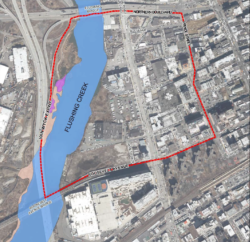
Designated study area in Flushing, Queens. Image credit: DCP
City Planning presented to community board draft findings and recommendations for brownfield improvements in Queen’s Flushing neighborhood. In 2011, under the New York State Brownfield Opportunity Area Program, the Flushing-Willets Point-Corona Local Development Corporation received a $1.5 million state grant to plan for the clean-up and rezoning of the Flushing waterfront. The Program was created to transform brownfields—vacant or underutilized properties—from liabilities to community assets. This is the second phase of the Brownfield Opportunity Area Nomination Report and Master Plan. Currently, the Department of City Planning is completing the report, the Flushing Waterfront Revitalization Plan. City Planning presented preliminary findings to Queens Community Board 7 on May 2, 2017.
The study focused on recommendations to improve the area west of College Point Boulevard between 36th Street and Roosevelt Avenue. Its objective is to guide mixed-use redevelopment of the waterfront properties with an expanded street network, including wider public walkways, which would connect to existing transportation grid but would be privately maintained. The area includes 116 tax lots on 32 acres.
The area is largely zoned as a C4-2 zoning district which allows for 3.4 floor area ratio for commercial use and residential development up to 2.43 floor area ratio, comparable to an R6 zoning district. The northern portion of the subject area is zoned as a M3-1 zoning district on the waterfront and M1-1 zoning district inland between College Point Boulevard and Prince Street, north of 36 Road. The manufacturing zoning allows for 2.0 and 1.0 floor area ratio respectively and no residential space.
City Planning noted that under current zoning developments are likely to maximize their floor area ratio by creating super-blocks with towers atop bulky bases. These formations are not conducive to the circulation of pedestrians, vehicles, light or air. City Planning estimated that maximum build out would create 1,172 residential units, 26,000 square feet of community facility space, 1,203,041 square feet of commercial space, and 106,310 square feet of warehouse space.
City Planning’s Brownfield Opportunity Area report recommends establishing a Special Flushing Waterfront District on a twelve-acre area along Flushing Creek that would replace the existing Waterfront Access Plan. The Department propose rezoning the northern portion of the area to an M1-2 zoning district with an R7A overlay, leaving the C4-2 zoning district in place. The report estimates that in the coming 10-years the redevelopment plan could potentially increase the current zoning potential by 222 residential units, 56-67 permanently affordable units and an additional 59, 684 square feet of commercial space.
Formal designation by the state would lead to a framework to help property owners with soil contamination on brownfield sites. The Brownfield Cleanup Program would provide increased tax credits for site remediation within the designated area to deal with potential ground soil contamination, including fuel oil, coal dust, industrial solvents, dyes, lubricants, paints and stains.
To view City Planning’s presentation to Queens Community Board 7, click here.
By: Jonathon Sizemore (Jonathon is the CityLaw Fellow and a New York Law School Graduate, Class of 2016).


