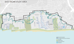
The City Planning Commission approved a plan to limit development in the flood zone of the East Shore to improve resiliency of the community. On August 9, 2017, the New York City Planning Commission issued a favorable report on the City Planning Department’s application to create a special zoning district on coastal areas of Staten Island. The zoning map amendment and zoning text amendments would cover portions of the Oakwood Beach, Graham Beach, and Ocean Breeze neighborhoods. The rezoning would limit future development in these highly flood vulnerable areas.
The application came as a result of the City’s Resilient Neighborhoods initiative, which was created after Hurricane Sandy to identify zoning and land use changes that will support the vitality and resiliency of communities in the City’s floodplain. The 40-block subject area is bounded by Olympia Boulevard to the north, Jefferson and Hunter Avenues to the west, Slater Boulevard and Seaview Avenue to the east, and Father Capodanno Boulevard to the south. The area is a low-lying geography of roughly four square miles that was hit particularly hard by coastal inundation during Hurricane Sandy.
Oakwood Beach, Graham Beach, and Ocean Breeze are currently zoned R3-1 and R3X with small area mapped with R3-2. The City Planning Department proposed the creation of an East Shore subdistrict within the Special Coastal Risk District. The subdistrict would limit future residential development to single-family detached residences and prohibit community facilities that include sleeping or overnight accommodations. New construction or enlargements of an existing building would require a CPC authorization.

Image credit: DCP
On May 16, 2017, Staten Island Community Board 2 voted 17-11 to recommend approval of the rezoning. On May 24, 2017, Staten Island Community Board 3 voted 27-0 to approve as well. On June 20, 2017, the Staten Island Borough President recommended approval.
In its report, the City Planning Commission found the rezoning of the East Shore to be appropriate. The amendments “would help limit flood vulnerability and guide future development.” The report noted that the rezoning would allow the elevation of existing buildings to occur as-of-right to make existing buildings safer.
CPC: East Shore Special Coastal Risk District, Staten Island (N 170374 ZRR; C 170373 ZMR) (Aug. 9, 2017).
By: Jonathon Sizemore (Jonathon is the CityLaw Fellow and a New York Law School Graduate, Class of 2016).


