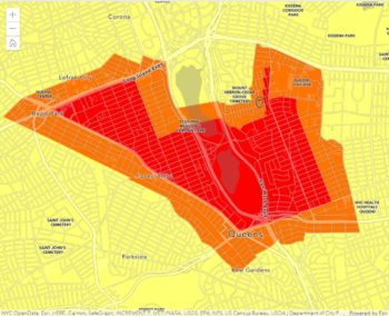
The “Find Your Zone” Map showing yellow, orange and red zones over several neighborhoods in Queens. Click to enlarge image. Image Credit: NYC Mayor’s Office/Office of Emergency Management
Indicated zones will undergo restrictions for a minimum of 14 days after the zone is identified. On October 7, 2020, Mayor Bill de Blasio announced the launch of the ‘Find Your Zone’ map, the City’s newest tool to help New Yorkers stay informed about the spread of COVID-19. The map allows users to enter an address to identify if that location is in a COVID-19 hotspot and what restrictions may apply to that zone for local schools, businesses, houses of worship, and other gatherings.
The map shows hotspots where COVID-19 cases are on the rise in yellow, orange, and red zones. Restrictions in all zones will be in effect for a minimum of 14 days, with the first restrictions beginning yesterday on October 8th.
In yellow zones, schools remain open but are subject to mandatory COVID-19 testing. Businesses will remain open, and both indoor and outdoor dining are still permitted, but limited to tables of up to four people. Gatherings in yellow zones are restricted to 25 people or less, but houses of worship can operate at 50 percent capacity.
In orange zones, schools will close, and high-risk businesses like gyms will also be closed. Indoor dining is not permitted, but outdoor dining is still allowed with a maximum of four people per table. Houses of worship may operate at a maximum 33 percent capacity and up to 25 inside. Gatherings are restricted to ten people or less, both indoors and outdoors.
In red zones, where the number of cases is most severe, schools are closed and all non-essential businesses will close. Both indoor and outdoor dining are not allowed, and restaurants are limited to take-out only. Houses of worship are limited to 25 percent capacity, with a maximum of 10 people allowed inside. Mass gatherings are prohibited.
The map was created by making State zone maps searchable through efforts of the Department of Health and Mental Hygiene (DOHMH), NYC Emergency Management, and the Department of Information Technology & Telecommunications (DoITT). The creation of the map follows an alarming spike in COVID-19 cases, primarily found in several neighborhoods in Brooklyn and Queens.
In a press conference on October 7th, Mayor de Blasio indicated that various City agencies will work on information outreach with affected communities to explain the changes and that the NYPD and DOT would put electronic signage at key intersections in the affected areas. The City will have 1,200 personnel in addition to State enforcement teams to enforce restrictions in these areas. Mass gatherings in restricted zones can result in up to $15,000 fines per day, and fines for not wearing face coverings can reach up to $1,000 a day. According to the Mayor, the increased pressure is in hopes of ending the hotspot as soon as possible. Over 10,000 COVID-19 tests were done in the week prior, and testing will be expanded in these areas.
As part of the map press release, Mayor de Blasio stated, “New Yorkers have been through so much together, and these next few weeks are critical in our fight against the pandemic. We are committed to giving New Yorkers the resources they need to stay safe and healthy in their communities.”
NYC Health Commissioner Dr. Dave A. Chokshi stated, “Throughout this outbreak New Yorkers have been the key to beating back the virus. This tool will keep residents informed about COVID-19 in their communities so that they can take necessary steps to keep themselves and their friends, families and neighbors safe.”
NYC Emergency Management Commissioner Deanna Criswell stated, “We are in this fight together, and we will continue to provide New Yorkers with the necessary resources to stay informed about the virus. The Find Your Zone map is a critical tool that makes it easy for individuals to find out whether they live, work, worship or attend school in a cluster zone.”
The map can be found by going to www.nyc.gov/COVIDZone or clicking here.
CityLand is continuing its ongoing coverage of the City’s recovery and response to the COVID-19 pandemic. For more coverage, click here.
By: Veronica Rose (Veronica is the CityLaw fellow and a New York Law School graduate, Class of 2018.)


The maps that have been posted lack readable streets read zones are the same.
The railroad pedestrian bridge at 67 th Ave (in the red zone) is a very bad place for virus contagion. Lots of foot, bike and motorcycle traffic. The mounted two wheeled vehicles are totally illegal. Un masked Joggers BAD.
When people cross the the bridge unmasked on the way to Temple on holiday or for other unmasked reasons it it a real hazard. THE BRIDGE IS TOO NARROW TO AVOID OTHERS!
The cops should issues summons for two wheeled vehicles and city should either post signs about masks or close the bridge.